

Safe and scary places: George Mason University at back to school time
Students, staff, planners, visitors and police construct George Mason University through spatial practices performed everyday. Space is subject to territorializing and deterritorializing processes (Duncan 1996:128) from multiple vantage points. For planners a building might be Southside, but for some women, the area behind that building it is “rape alley” a scary area or territory where caution is in order. All sections of the Johnson Center food court might look the same to a casual observer but might be organized spatially and temporally by users. I used GIS methodologies to create maps of gendered space during the fall of 2008 on the George Mason University Campus, Fairfax Virginia, translated those subjective understandings of safe and scary places into a more concrete representation.
Safe and scary places on campus might be a “reflection of gendered power relations” in relation to “inter-subjective power-related processes of producing space” (Koskela: 1999). Gendered power relations are most forcefully expressed through acts of sexual violence against women. Most sexual violence on campus occurs in intimate environments among friends or acquaintances. Sexual violence by strangers is relatively rare, but contributes to a climate of fear.
Gender exclusion is, “a mosaic of complex processes of power and gender relations” (Koskela: 1991:121). Those complex processes are spatial as well as social, since spatial practice is dialectical (Soja 2000). Lefebvre refers to masculine dominance over space as phallocentric since space itself is gendered as female and time as male. Time conquers space and controls it (Lefebvre 1991). Scary space is a consequence of masculine dominance over space (Pain: 1991; Koskela: 1999), experienced violence, sexual harassment, or threat of violence acts as a mechanism to police gender exclusion.
My objective is to make visible cartographically the understandings of “conceived space” which guide everyday spatial practices such as walking across campus. Security as well as sexual violence is a spatial practice, which can be mapped or counter-mapped. Ultimately mapping is a political act, in the same way as typologies and classification schemes partition knowledge, scientific mapping can partition space. Massey claims that by creating grids, a universal order of gendered, capitalist space was imposed on the world, a space that is and was socially constructed as a surface to be carved up into discrete entities like so many parcels of property (Massey 2007). It is a fixed space.
Rather than rejecting Cartesian mapping, I hacked it, aware of its representational limitations and the universalistic assumptions which under gird the conceptualization of “space-time envelopes” (Massey: 2005). Essential sections, slices of time, are impossible to construct (Althusser: 1968; Massey: 2007). All maps omit or draw attention to certain features depending on the intent of the map maker. Census numbers never tally up, road networks are never complete, and buildings are missing, even for small areas like George Mason University.
The project was undertaken with specific goals both methodological and substantive. The methodological goal was to integrate qualitative data collection methods, and devising a method to quantify and visualize cognitive maps, the “mental maps” that people use to make everyday space intelligible. I sought to compare those mental maps to those produced using a movement model based on desire lines, incorporating measurable sex crime events. The substantive goal was interpretive, to understand how space is imagined and claimed by those who live it and the spatial practices that define perceived, conceived and lived space in relation to gender.
I combined divergent methods to create maps and narrative that articulate a “view from below” informed by the perspectives of several critical geographers including Linda McDowell, Doreen Massey, Edward Soja and Henri Lefebvre. GIS software replicates corporate structures in hierarchies of classes, class features. As such it is a masculine view, frozen in code. Using off the shelf software to create a view from below when it was designed as technology of dominance requires reframing the technology and its output theoretically. Mei Po Kwan argues that the connection between GIS and positivism is neither necessary nor inevitable and that a feminist GIS might be a valuable addition to the repertoire of methods (Kwan 2002). I applied GIS technology to expose the view from below cartographically.
Linda McDowell echoes Donna Haraway and Foucault finding that “the ‘view from below’ is likely to include a clearer perspective on the conditions of oppression than what she (Donna Haraway) termed the ‘view from nowhere’” outside of space and time. “Social space is a social product” (Lefebrve1991:26) concealed by transparency and opacity, it can be described by” a conceptual triad, spatial practice, representations of space, and representational spaces” (Lefebrve1991:33). Doreen Massey considers space as multiple socially and politically constructed trajectories; linked to time but distinct. Space can be thought of as a product of interactions, predicated on plurality, and always under construction (Massey 2005:9).
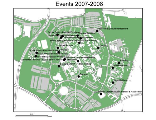
I used data that were both quantitative and qualitative. I had already obtained from facilities management base map GIS data which I updated with new buildings and pedestrian pathways using campus CAD drawings. The George Mason Police Department was gracious to share their sex crime data for the year 2007-2008 with me.
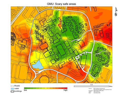
Qualitative data I collected included field notes from observations, a student focus group( a meeting of the Feminist Ninjas), and informal interviews with the George Mason University Assistant Police Chief, the campus police researcher and the Director of Sexual Assault Services at GMU.The most salient theme that emerged during interviews was the perception of areas of threat or risk. Threatening environments are not necessarily dangerous but feel scary, as opposed to places that feel safe. The dichotomy of safe and scary space can be linked to another dichotomy, dangerous and not safe places.
Sketch maps collected during interviews were translated into surface representations of safe and scary areas and evaluated in relation to other spatial data. These include space syntax (the visual coherence of a space), likely movement patterns and incidents of sexual violence in the study area. Likely movement patterns were mimicked using a Delaunay triangulation and to create desire lines. “Desire lines” or the likely direction of travel on campus might be more relevant than space syntax when considering safe and scary areas. Campus insiders are quite familiar with the layout of buildings making visual coherence a less important factor.
I was less interested in interviews than collecting cognitive maps. The cognitive map collection technique was adapted from Kevin Lynch’s approach of unstructured interviews and sketch maps (1960). Rather than ask participants to make sketch maps on blank paper as Lynch did, I provided base maps to draw on with red and green markers. I collected sketch maps from the Feminist Ninjas and the Director of Sexual Assault Services. Other individuals asked if they could make some as well, after commenting on the completed maps, I was happy to oblige. Some of the sketch maps are still un-digitized but relevant none the less, since they expose some scale effects at work.
After the police department sent me the locational data for sex crimes I geo-coded the events, making them into a layer in my database for comparison with the other data in reference maps. Geo-coding refers to the process of placing features or events into a coordinate system for further examination. I did this manually using the approximate locations from police records.
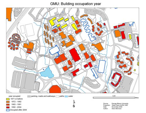
For visitors or other campus outsiders, navigating the campus is not intuitive. Becoming a member of the campus community is a learning process as suggested by the many summer time orientation days and temporary signing program installed during the first days and weeks of the fall term. Social space is sedimented (Massey 2005).The George Mason campus can be periodized by date of occupation: the architectural motifs of campus structures communicate: community college extension, commuter school, office park, research center, University City. From naturalized pathways through wooded areas to gridded mixed use residential, commercial, and office space structures at Southside in the Northeast Quadrant development, perceived space is planned space, spreading outward from the small core group of buildings built in the early 1970s to the present. The architectural embellishments on those core buildings are modest while Research I reads “Science and Technology” with its observatory tower.
George Mason is a social product structured by zoning, capital expenditure plans and state budgets. George Mason is creating and being created in relation to multiple scales and geographic features in a mix of contending social forces. Campus activity areas were designed to separate public and private zones, such as pubic study areas being separate from private dormitory areas, much as zoning and land use ordinances fragment “post-metropolis” more generally (Soja 2000). TThe perimeter road is the connective tissue joining George Mason with the community, but also separates the campus from the community. The campus itself is organized around a series of quads but these quads are not clearly articulated in relation to each other or to the overall scheme.
George Mason is embedded in territorial entities like federal, state and local governments, networks such as transnational migration patterns. Field observations of pedestrian traffic across the campus allude to larger socio-spatial processes operating on scales from the global to the local. Watching movement across Mason, snippets of many languages are heard, while clothing ranges from veils to shorts suggesting the transformation of Northern Virginia in recent decades.
According to Connie Kirkland, Sexual Assault Services Director at George Mason University, most sexual violence on campus is committed in private by known persons not by strangers in public. Dorm rooms and residence halls are the riskiest sites, but attacks do occur in public spaces, creating gender boundaries at both scales. Connie marked out all residence halls as risky places, while singling out the relatively low traffic wooded areas near the old dinning hall as particularly unsafe. A sexual attack had occurred there in recent weeks. This event did not appear in the police data but was mentioned by interviewees at the time I was collecting data.
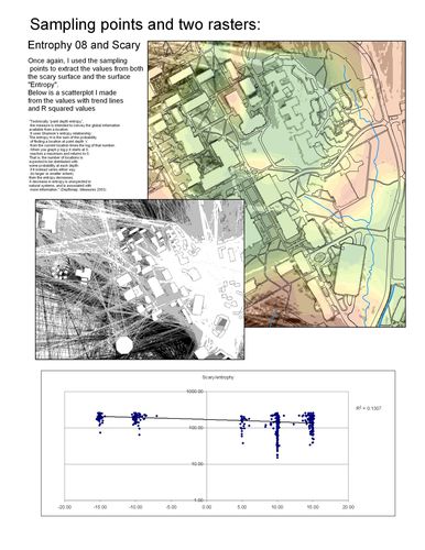
What stood out for me in the conversation with the Feminist Ninjas was the terminology — areas were “scary” instead of dangerous. The group felt lighting and foot traffic were the most important factors contributing to safety and/or comfort level. Visual coherence did not emerge in the course of the discussion and was not—as scatter plots showed—a major factor related to scary or safe areas as identified by the Feminist Ninjas.
Scary and safe, safe and unsafe are different concepts overlapping but not equivalent. For the Director of Sexual Assault Services the wooded area between the residence halls and the dining hall raised concern. When examining the cognitive maps, the Assistant Chief of police found them logical and reasonable assessments of risk.
Like the ebbs and flows of pedestrians, sexual violence ebbs and flows. In the 23 months from January 2007 through October 2008, the largest number of incidents was caused by a single person (26%). Divided between indoor (65%) and outdoor locations (35%); public (57%) and private (43%) the pattern of events were neither clustered nor dispersed and therefore random. Outside events, however were scattered across the northern part of campus, closest to the campus boundaries and on the periphery of well traveled and well lit areas
.On the Feminist Ninja cognitive map, outdoor sex crime events fell outside the area identified as safe but the scariest areas—parking lots—were not the sites of most sex crimes. The Feminist Ninja cognitive map matched closely estimations of likely movement patterns. Gender boundaries are enforced at the margins and in the most intimate spaces where the force of community weakens.
Scale effects were evident in the individual interviews and sketch maps. Rather than drawing big areas, specific locations were singled out as scary. Thompson Hall was singled out as very scary. The area just behind the new dinning facility was singled out as “rape alley” not because of any known incidents but because it has dark corners and blind spots. Parking lots, for a particular non-traditional woman student, a classmate of mine, were not scary because they are well lit. For her, the pathways leading to the parking lot were areas of risk.
Scale effects were also evident in sex crime incidents, occurring inside and outside buildings with lot of foot traffic like the Johnson Center. High traffic areas have low traffic areas within them. A parking deck might be dark and lonely but still have spot of activity lending a sense of security.
It appears that the inter-subjective process of creating mental maps exhibits expert knowledge of local settings as lived everyday. Cognitive or mental maps are a mechanism to control uncertainty as well as a tool to navigate a landscape. Crime happens where it happens but mental maps allow us to manage risk. People empower themselves. Exercising caution in scary areas increases a sense of control over personal safety.
In the course of collecting data it became clear that women more than men find personal safety to be a major concern, even in a relatively safe place like Mason. It is less surprising in the context of the dynamics of sexual violence. If personal space is the place of greatest risk, then threat levels must be assessed everywhere.
Local knowledge is expert knowledge. Counter-mapping can make local knowledge visible and quantifiable in a way that conforms to the culture of planning. As an action-research tool, mapping could be a part of a participatory planning process allowing marginalized people the opportunity to engage in a discourse that excludes them.
The view from below does seem to embody lived experience as the Feminist Ninja cognitive map corresponded most closely to the patterns of reported sexual violence. The Ninja’s cognitive map also conformed to the estimated intensity of pedestrian movements across the campus. Scalar effects were evident in that individual cognitive maps made in one on one conversation singled out specific spots that were scary or safe, both inside and outside buildings.
References
Duncan, Nancy (1996) “Bodyspace: Destabilizing geographies of gender and sexuality” London: Routledge
Koskela, Hille (1999) “‘Gendered Exclusions`: Women’s Fear of Violence and Changing Relations to Space” Geographiska Annaler. Series B. Human Geography 81(2) 111-124
Kwan, Mei-Po (2002) “Feminist Visualization: Re-envisioning GIS as a Method in Feminist Geographic Research” Annals of the Association of American Geographers 92(4) 645-661
Kwan, Mei-Po, and Lee, Jiyeong (2004) “Geovisualization of human activity patterns using 3-D GIS: A time geographic approach” In “Spatially integrated social science”, ed. M. F.Goodchild and D. G. Janelle, 48–66. New York: Oxford University Press.
Lefebvre, Henri; Nicholson-Smith, D. trans. (1991) “The Production of Space” Malden Mass: Blackwell
Lynch, Kevin (1960) “The Image of the City” Boston: MIT Press.
Massey, Doreen (2005) “For Space” London: Sage
McDonald, Linda (1996), “Spatializing Feminism: Geographic Perspectives” in Duncan, Nancy (1996) “Bodyspace: Destabilizing geographies of gender and sexuality” London: Routledge
Pain, R (1991) “Space, sexual violence and social control: integrating geographical and feminist analyses of women’s fear of crime” Progress in Human Geography (15) 415-431
Soja, Edward (2000) “Postmetropolis: Critical Studies of Cities and Regions” Malden, Mass: Blackwell Publishing Ltd.